Google Maps puts Pulpit Rock on Street View
The Local Norway - [email protected]
Published: 3 Mar, 2015 CET.
Updated: Tue 3 Mar 2015 14:32 CET
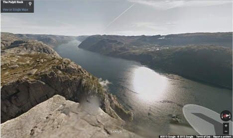
Google Maps staff have trekked to the top of Pulpit Rock, one of Norway’s tourist attractions, making stunning views of the Lysefjorden available to anyone everywhere over the internet.
Last summer, Google’s Street View Trekker, a backpack Google uses to shoot places its fleet of Street View cars cannot reach, was brought to Lysefjorden, and carried all the way along the precipice to Pulpit Rock.
The new images, which only became available today, give viewers the experience of trekking through one of Norway's most extraordinary landscapes.
“This gives Lysefjorden and Pulpit Rock fantastic exposure, both in Norway and internationally,” said Harald Skaarn of Google Norway.
Every year some 250,000 people take the five-hour hike to the top of Pulpit Rock to enjoy the breath-taking beauty of the scenery. The trek is not for those with vertigo, as the cliff face drops 604 metres into the fjord.
Those managing the site hope that more international visitors will now be inspired to visit the plateau.
"We are in the company of the pyramids of Egypt, the Great Wall of China and Machu Pichu," Audun Rake of the Pulpit Rock Foundation, which manages the site, told Stavanger Aftenblad. "These are places everybody knows. It's amazing that Google has put the Pulpit on such an exclusive list."
Comments
See Also
Last summer, Google’s Street View Trekker, a backpack Google uses to shoot places its fleet of Street View cars cannot reach, was brought to Lysefjorden, and carried all the way along the precipice to Pulpit Rock.
The new images, which only became available today, give viewers the experience of trekking through one of Norway's most extraordinary landscapes.
“This gives Lysefjorden and Pulpit Rock fantastic exposure, both in Norway and internationally,” said Harald Skaarn of Google Norway.
Every year some 250,000 people take the five-hour hike to the top of Pulpit Rock to enjoy the breath-taking beauty of the scenery. The trek is not for those with vertigo, as the cliff face drops 604 metres into the fjord.
Those managing the site hope that more international visitors will now be inspired to visit the plateau.
"We are in the company of the pyramids of Egypt, the Great Wall of China and Machu Pichu," Audun Rake of the Pulpit Rock Foundation, which manages the site, told Stavanger Aftenblad. "These are places everybody knows. It's amazing that Google has put the Pulpit on such an exclusive list."
Join the conversation in our comments section below. Share your own views and experience and if you have a question or suggestion for our journalists then email us at [email protected].
Please keep comments civil, constructive and on topic – and make sure to read our terms of use before getting involved.
Please log in here to leave a comment.